0
0.0
Feb 23, 2023
02/23
by
KRON
tv
eye 0
favorite 0
quote 0
mountains, east bay hills. and even a chance of some flurries right there around twin peaks about davidson in san francisco itself. now as far as future casco spotty showers will continue through the day today. really picking up activity into the evening tonight, though, this is 07:00pm, much more widespread rainfall. and you see those areas of yellow and orange pockets of heavy rain pushing through as well. maybe even a roll of thunder, too. and snow falling to increasingly low elevations as we make our way on into tomorrow morning. so quite the active next. 24 hours. rainfall between here into early next week of around an inch and then out up on top of that, another inch or 2 into next week as we see even more rainfall, winds calmer than they had been. but we will be seeing them picking up into the evening tonight. so do watch for that. daytime highs today in the upper 40's to low 50's and looking ahead at our next 7 days, we're going to see temperatures remaining pretty steady. those upper 40's to low 50's a
mountains, east bay hills. and even a chance of some flurries right there around twin peaks about davidson in san francisco itself. now as far as future casco spotty showers will continue through the day today. really picking up activity into the evening tonight, though, this is 07:00pm, much more widespread rainfall. and you see those areas of yellow and orange pockets of heavy rain pushing through as well. maybe even a roll of thunder, too. and snow falling to increasingly low elevations as...
0
0.0
Feb 23, 2023
02/23
by
KRON
tv
eye 0
favorite 0
quote 0
mountains, the east bay hills in the north bay hills. tonight's the night that we're going to see snow levels low drop the lowest frost advisories and freeze warnings in expected it. and in effect, as we speak right now and snow level tonight getting even lower. keep your eye out for some flurries tomorrow morning. if you're up around mount hamilton, multiple feet of snowfall, multiple inches for the north bay and east bay mountains. now, pockets of rainfall continue on and off through the day today. we will see snow remaining for the most part above 1000 feet today. heavy pockets of rain fall tonight and snow level dropping down to in some cases as low as 8, even 500 feet in elevation. that's when areas like the twin peaks may see a few flurries this evening. as far as rain goes, we've got another inch of it this week and another one to 2 inches on top of that into next week. so a pretty busy forecast. winds are going to be calmer today than they have been but still gusting 20 to 30 miles per hour. and as far as daytime highs go only in
mountains, the east bay hills in the north bay hills. tonight's the night that we're going to see snow levels low drop the lowest frost advisories and freeze warnings in expected it. and in effect, as we speak right now and snow level tonight getting even lower. keep your eye out for some flurries tomorrow morning. if you're up around mount hamilton, multiple feet of snowfall, multiple inches for the north bay and east bay mountains. now, pockets of rainfall continue on and off through the day...
0
0.0
Feb 24, 2023
02/23
by
KRON
tv
eye 0
favorite 0
quote 0
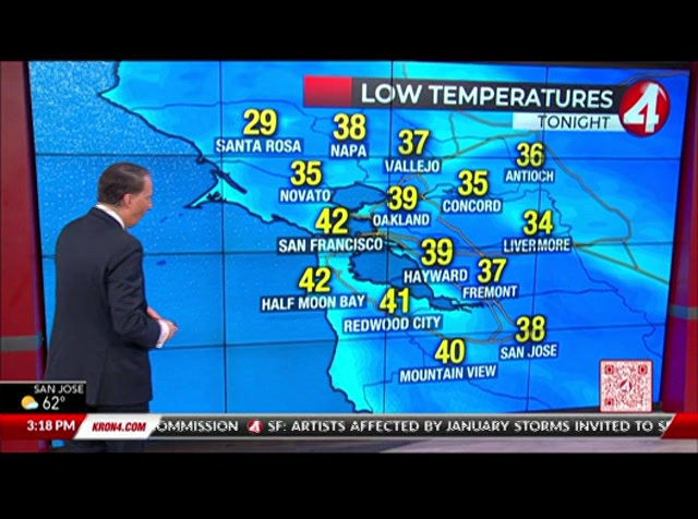
and east bay hills, south bay mountains remain in these through 11:00am. this morning. we're also under freeze warnings and frost advisories through 09:00am this morning with temperatures falling really, really low. now we are warming up along the bay shore for it to be consistently rainy. if you are seeing any sort of frozen precipitation, it's mostly hail or sleet that you're seeing in these areas. that's for san jose mountain hayward at 39 degrees. freeman. 38 livermore. you're in a really chilly 36 cloverdale. we saw the snow overnight. 33 degrees right now up towards mendocino and lake counties. it is solid snowfall up there traveling between lake mendocino counties down into napa and sonoma counties. really, really rough. go as we're seeing a lot of snow packed roads up there this morning. winds not as consistently windy as we had been seeing 15 to 20 miles per hour. gusts from the 30's and 40's this morning to the 40's to just barely low 50's this afternoon. it's a cold day through and through, but we will get clear come the afternoon. so something
and east bay hills, south bay mountains remain in these through 11:00am. this morning. we're also under freeze warnings and frost advisories through 09:00am this morning with temperatures falling really, really low. now we are warming up along the bay shore for it to be consistently rainy. if you are seeing any sort of frozen precipitation, it's mostly hail or sleet that you're seeing in these areas. that's for san jose mountain hayward at 39 degrees. freeman. 38 livermore. you're in a really...
0
0.0
Feb 27, 2023
02/23
by
KRON
tv
eye 0
favorite 0
quote 0
mountains, but east bay hills. that's going to continue through tuesday. so we are tracking this atmospheric river tapping into a plume of subtropical moisture. going to give us widespread rain. so right now we're going to start to see that drying trend. still seeing those showers out there in the south bay. but for the rest of the bay area, we're already drying out. that's going to continue throughout tonight. but the bulk of that river first going to ride for those of you in the north bay by monday morning. this is going to have a negative impact on your morning commute. so plan ahead and drive safely could see thunderstorms, hail and gusty winds throughout your monday morning commute with some scattered showers by monday afternoon with the 3rd round of rain arriving tuesday through wednesday. so we could see anywhere from about 3 quarters of an inch of rain or less doubled those amounts through wednesday. more my full forecast and a look at your sierra outlook in just a few minutes. back to dan and noelle. >> th
mountains, but east bay hills. that's going to continue through tuesday. so we are tracking this atmospheric river tapping into a plume of subtropical moisture. going to give us widespread rain. so right now we're going to start to see that drying trend. still seeing those showers out there in the south bay. but for the rest of the bay area, we're already drying out. that's going to continue throughout tonight. but the bulk of that river first going to ride for those of you in the north bay by...
0
0.0
Feb 23, 2023
02/23
by
KRON
tv
eye 0
favorite 0
quote 0
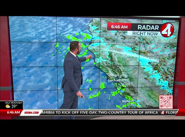
now, the east bay hills right now are looking pretty good. we don't have any fog out there, but we do have these spotty showers moving across the bay area. it's solid snowfall for the north coast as well as the sierra nevada in a mix of snow and rain for the bay area. snow up there widespread across the santa cruz mountains as well as up into the mount hamilton area above san jose. you're also seeing it on mission pekin note. blow earlier today saw some flurries on mount tam and i would not be at all surprised if this morning we saw some flurries around santa rosa northward from there. we're under winter storm warnings for the north bay mountains, east bay hills and mountains as well as the santa cruz in diablo range is of the south bay. these will take effect later on today into tonight. tonight into tomorrow morning will be our best chance of snow falling as low as areas like twin peaks in san francisco and the east bay hills. we also have frost advisories and freeze warnings in effect through the day. now, futurecast of snowfall total show
now, the east bay hills right now are looking pretty good. we don't have any fog out there, but we do have these spotty showers moving across the bay area. it's solid snowfall for the north coast as well as the sierra nevada in a mix of snow and rain for the bay area. snow up there widespread across the santa cruz mountains as well as up into the mount hamilton area above san jose. you're also seeing it on mission pekin note. blow earlier today saw some flurries on mount tam and i would not be...
0
0.0
Feb 23, 2023
02/23
by
KRON
tv
eye 0
favorite 0
quote 0
winter storm warnings above 1000 feet in elevation across the north bay and east bay hills. and in the south, south bay mountains as well. and tonight we go back into some freeze warnings and frost advisories too. temperatures falling again well below freezing. now. our temps right now climbing back into the 40's. so we're getting there this afternoon, only upper 40's to low 50's. so it's staying pretty chilly all day long today. we're really going to be looking out for the spotty showers skies tonight. it's going to pick right back up and then, yeah, maybe a few flurries. i'm excited for everyone to send in their snow videos from tomorrow. all please do that. and just be where the commute that you're going want to tune in extra early, going to be certainly busy tomorrow. so also just factor in bart. now is 20 minute delay or because the weather because the weather, so we know it's going to happen. right, someday, see you tomorrow repaired, . . phil. teen drivers-- when i got to the accident scene, i found out that my son had passed away. dr. phil (voiceover): --and their ne
winter storm warnings above 1000 feet in elevation across the north bay and east bay hills. and in the south, south bay mountains as well. and tonight we go back into some freeze warnings and frost advisories too. temperatures falling again well below freezing. now. our temps right now climbing back into the 40's. so we're getting there this afternoon, only upper 40's to low 50's. so it's staying pretty chilly all day long today. we're really going to be looking out for the spotty showers skies...
0
0.0
Feb 24, 2023
02/23
by
KPIX
tv
eye 0
favorite 0
quote 0
in the east bay hills, it is just scattered showers. but you see a little blue showing up right there. snow has gotten down as low as the ridge tops there, which means grizzly peak at 1800 feet has had beautiful snow all morning. we have been looking at that as well with our live shots. justin andrews has been there to share it with us all morning long. it really has been very cool to look at. and the north bay has had its fair share of snow. and a that is higher than 1000 feet will have a light dusting of snow this morning. if you are not getting snowed on, you will be able to get to see snow wherever you are in the bay area. scattered showers staying with us this afternoon. there is an uptick in snow as we go through late afternoon. watch this wave. saturday morning gets us to the predawn hours of saturday. more snow in the north bay mountains. by saturday afternoon, it will come to an end. then there is another system coming our way. another storm comes in for the second half of sunday. we will look at that in our seven-day forecast.
in the east bay hills, it is just scattered showers. but you see a little blue showing up right there. snow has gotten down as low as the ridge tops there, which means grizzly peak at 1800 feet has had beautiful snow all morning. we have been looking at that as well with our live shots. justin andrews has been there to share it with us all morning long. it really has been very cool to look at. and the north bay has had its fair share of snow. and a that is higher than 1000 feet will have a...
0
0.0
Feb 23, 2023
02/23
by
KRON
tv
eye 0
favorite 0
quote 0
this is the north bay mountains, the east bay hills and mountains, as well as the blows in the santa cruz mountains. also some freeze warnings and frost advisories in effect throughout the course of the morning. current temperatures are well down in the 30's, san jose at 38 degrees mountain view. fremont san mateo at 39 conquer dublin livermore in the upper 30's petaluma at 30 and santa rosa down to 27 degrees. watch for flurries from nevado up to cloverdale this morning. definitely an active one but winds at least a little calmer than yesterday. i'm going to be talking all about where to expect snow and tonight, an even better chance of it at lower elevations. still to come right now. all right, john, thanks so that we are tracking your morning drive if you're heading into the city right now. >> probably going to take about 8 minutes to make that commute this morning again, you want to give yourself a lot of extra time because some of those wind chills might be frozen. 12 minutes 80 to 101 traveling across towards the peninsula. a richmond center fell bridge about 7 minutes there. a
this is the north bay mountains, the east bay hills and mountains, as well as the blows in the santa cruz mountains. also some freeze warnings and frost advisories in effect throughout the course of the morning. current temperatures are well down in the 30's, san jose at 38 degrees mountain view. fremont san mateo at 39 conquer dublin livermore in the upper 30's petaluma at 30 and santa rosa down to 27 degrees. watch for flurries from nevado up to cloverdale this morning. definitely an active...
0
0.0
Feb 27, 2023
02/23
by
KRON
tv
eye 0
favorite 0
quote 0
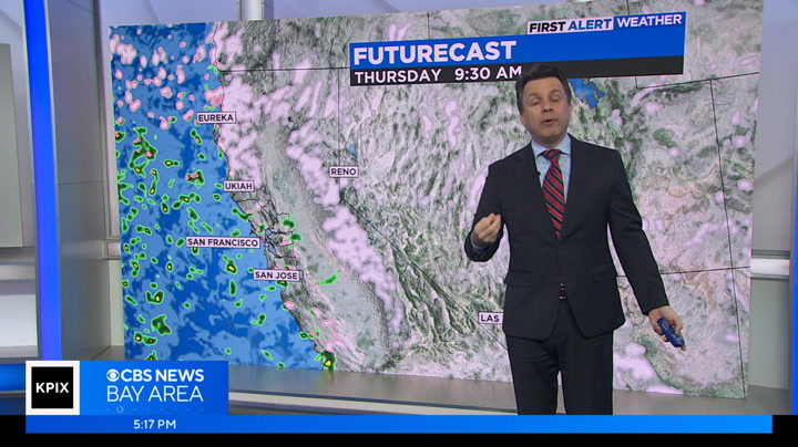
for the east bay hills, including eastern santa clara hills. you're going to be under that winter weather advisory starting at 10 o'clock monday. both set to expire by tuenday afternoon with elevations above 3,000 feet, getting anywhere from 5 to 10 inches of snow. with that slushy snow and rain mixture at the lower level. so let's take a look at these upcoming storms. the second round that's going to arrive early monday morning, lasting through monday night. and we're going to see for hills and mountains a little bit more than an inch of rain for the bay area. we're going to get anywhere from a quarter of an inch to three-quarters of an inch of rain. >> slightly lesser amounts with story number 3 on tuesday through wednesday, just about half an inch of rain or less. but the same amount for local hills and mountains. but this is going to be severe storms colder, unstable air mass making its way. that's why could see gusts upwards of 50 miles per hour with hail and even thunderstorms. if any do form. so let's take a look at radar for it. very dr
for the east bay hills, including eastern santa clara hills. you're going to be under that winter weather advisory starting at 10 o'clock monday. both set to expire by tuenday afternoon with elevations above 3,000 feet, getting anywhere from 5 to 10 inches of snow. with that slushy snow and rain mixture at the lower level. so let's take a look at these upcoming storms. the second round that's going to arrive early monday morning, lasting through monday night. and we're going to see for hills...
0
0.0
Feb 23, 2023
02/23
by
KRON
tv
eye 0
favorite 0
quote 0
, east bay mountains and hills, santa cruz mountains and the diablo range. this is going to be our evening ahead of us with the lowest elevation snowfall. the best chance of precipitation and accumulation of snow fall in areas that haven't seen in years. so this is one to watch really closely. you know, we're going to be watching it hour by hour minute by minute. freezing temps with warnings. frost warnings are frost advisories and freeze warnings in effect for really almost all the bay area future cast of snowfall totals is showing you the heaviest accumulations likely tonight up in the diablo is right around mount hamilton, but also chance of some flurries here. and there in areas like even the hills of san francisco up a top twin peaks, which is that 922 feet for your peak elevation. there. snow level right now is right around 1000 feet. so that's just right above it. we're getting really close to some of these areas that haven't seen it in a minute. futurecast also shows you that we do have the spotty showers through the morning. we'll be keeping you upd
, east bay mountains and hills, santa cruz mountains and the diablo range. this is going to be our evening ahead of us with the lowest elevation snowfall. the best chance of precipitation and accumulation of snow fall in areas that haven't seen in years. so this is one to watch really closely. you know, we're going to be watching it hour by hour minute by minute. freezing temps with warnings. frost warnings are frost advisories and freeze warnings in effect for really almost all the bay area...
0
0.0
Feb 9, 2023
02/23
by
KRON
tv
eye 0
favorite 0
quote 0
in the east bay hills. nothing more than that, though. very, very short lived. another sprinkle or 2 possible early saturday morning. then it's nice and clear and smooth sailing the rest of the weekend on into valentine's day next tuesday. now temperatures today will be in the 60's. whether you're at the coast in san francisco and then looking at a few low 70's mixed into such as in areas like san jose all the way up to 70 degrees today. same for you in campbell. really nice february weather right here. and with all that sunshine, it's going to feel extra good. oakland at 66, same for you in walnut creek and danville. well, the way ben the show at 64 in santa rosa, that 67, here's a look ahead. temperatures out their remaining a little bit on the mild side today, but not so much come friday and saturday. that's that weak system that pushes in a drop in temps back into the upper 50's. a lot of cloud cover in that slight chance of sprinkles friday night into saturday morning. clear things right back out witho
in the east bay hills. nothing more than that, though. very, very short lived. another sprinkle or 2 possible early saturday morning. then it's nice and clear and smooth sailing the rest of the weekend on into valentine's day next tuesday. now temperatures today will be in the 60's. whether you're at the coast in san francisco and then looking at a few low 70's mixed into such as in areas like san jose all the way up to 70 degrees today. same for you in campbell. really nice february weather...
0
0.0
Feb 23, 2023
02/23
by
KRON
tv
eye 0
favorite 0
quote 0
the north bay hills, east bay hills and then the santa cruz and diablo range is of the south bay. snow levels expected to fall even further. and a winter weather advisory for parts of this year to we have winter. we have frost advisories and freeze warnings. i should say for the rest of the bay area because temperatures are getting so cold out there dropping below freezing for parts of the north bay. watch tonight for some snowfall in areas like santa rosa on up into northern sonoma county. even a few flurries possibly sticking at the top of twin peaks. and then multiple feet of snow at the top about hamilton tonight. as for our daytime, we can expect hours today to bring spots of sunshine. also, some areas of rain and even snow fall at higher elevations. the spotty showers will become more and more widespread into the evening and heavy pockets of rain fall on into the close of the day today. areas like the towards midnight tonight seeing some heavy out down. bur a areas of heavy rainfall pushing in and then snowfall up in the north bay becoming most likely on into early morning h
the north bay hills, east bay hills and then the santa cruz and diablo range is of the south bay. snow levels expected to fall even further. and a winter weather advisory for parts of this year to we have winter. we have frost advisories and freeze warnings. i should say for the rest of the bay area because temperatures are getting so cold out there dropping below freezing for parts of the north bay. watch tonight for some snowfall in areas like santa rosa on up into northern sonoma county....
0
0.0
Feb 24, 2023
02/23
by
KRON
tv
eye 0
favorite 0
quote 0
you can see that transition zone there in the east bay hills. i'm also looking really closely at i-80 once you get north east of la home on a pass, fairfield and vacaville as you drive through the hills there. little spot of snowfall that you're going to be traversing through right there on i-80, as well as up 505 north of vacaville through winters on up towards highway 5. 101 has been really rough this morning. it's a mixture of rain. we had some sleet up there as well, which has resulted in really slick conditions of both marin and sonoma counties. you go north of santa rosa, north of healdsburg. that's where you're seeing snowpack conditions on 1, cloverdale reports of people being stuck in the snow up there during overnight hours because of just how heavy that snow really was coming down there. as for most of the bay area, it's rainfall right now. this is really inundated. most of our bridges, the richmond center fell bridge as well as the bay bridge is. you can see in the midst of some of those heavier showers right now, including san franc
you can see that transition zone there in the east bay hills. i'm also looking really closely at i-80 once you get north east of la home on a pass, fairfield and vacaville as you drive through the hills there. little spot of snowfall that you're going to be traversing through right there on i-80, as well as up 505 north of vacaville through winters on up towards highway 5. 101 has been really rough this morning. it's a mixture of rain. we had some sleet up there as well, which has resulted in...
0
0.0
Feb 26, 2023
02/23
by
KRON
tv
eye 0
favorite 0
quote 0
bay hills. still tracking light rain and snow showers out there right now for your saturday night. believe it or not, and we could get anywhere from 10 to 20 inches of fresh powder for our highest peaks in the east bay hills. santa lucy range and even santa cruz mountains in the coming days with not one but 3 rounds of wet weather. so let's track the first round that was going to impact the 2nd half of your weekend right now to our north over portland. but we're going to see future cast for tracking light scattered showers by sunday morning in the north bay for the rest of the bay area is going to arrive early in the afternoon before it shifts to the south and east exiting those of you in san jose by around 4 o'clock for your sunday afternoon. so this is going to be a relatively fast moving storm, the weakest of the upcoming 3 storms. and this was going to bring us about a quarter of an inch of rain or less. but it's going to be mondays, atmospheric river, not only going to bring us a widespread
bay hills. still tracking light rain and snow showers out there right now for your saturday night. believe it or not, and we could get anywhere from 10 to 20 inches of fresh powder for our highest peaks in the east bay hills. santa lucy range and even santa cruz mountains in the coming days with not one but 3 rounds of wet weather. so let's track the first round that was going to impact the 2nd half of your weekend right now to our north over portland. but we're going to see future cast for...
0
0.0
Feb 21, 2023
02/23
by
KPIX
tv
eye 0
favorite 0
quote 0
diablo, this is more like the potential for east bay hills like along skyline boulevard. anything that is 1000 feet or above could get a light dusting, could be major regulations, and it will certainly be a talker, and will catch people's attention. a lot more snow on mt. hamilton and the santa cruz mountains of the potential for more impact in this scenario, where we have more infrastructure, roads, and communities that are much higher above that 1000 foot level. santa cruz mountains might have a bigger impact and of course the northbay mountains have always been a place to get snow but the focus of the system what's to put more from santa cruz mountains south. more snow in the sierra but for holiday travel concerns over there, does not start until tuesday afternoon. and then, it will really go. we look more at the sierra and snow story coming up in the next half hour, we will spent more time on just how unique this system is, and what it took for the atmosphere to be able to give us these unique circumstances. you can see it has a chance of scattered showers in the seve
diablo, this is more like the potential for east bay hills like along skyline boulevard. anything that is 1000 feet or above could get a light dusting, could be major regulations, and it will certainly be a talker, and will catch people's attention. a lot more snow on mt. hamilton and the santa cruz mountains of the potential for more impact in this scenario, where we have more infrastructure, roads, and communities that are much higher above that 1000 foot level. santa cruz mountains might...
0
0.0
Feb 26, 2023
02/23
by
KGO
tv
eye 0
favorite 0
quote 0
and it even brings snow toward the santa cruz mountains in the east bay hills. we could see anywhere between two and 4 inches, and 10 or more in the east bay. and tuesday another system comes in. rainfall amounts would be anywhere between half an inch to an inch. and lows tonight will be c in the 30's for parts of the north bay. 40's around the rest of the bay and then it is going to be even cooler on thursday night, tomorrow's highs will be in the low 50's. here is the accuweather 7-day forecast. rain tomorrow and snow, colder on monday, tuesday we have our final system that continues through wednesday. it will be very chilly thursday even though we have sunny warmer days on thursday friday and possibly wet into next weekend. >> sports with chris alvarez. >> pickle ball allows -- for when eight-year-old camper, that experience has been life-changing. >> can we get a basketball place -- please? >> it's been an inseparable combination since he became airr of 2022 at a warriors camp in front of chase center. >> how much fun do you have a passed ball camp? >> a lot
and it even brings snow toward the santa cruz mountains in the east bay hills. we could see anywhere between two and 4 inches, and 10 or more in the east bay. and tuesday another system comes in. rainfall amounts would be anywhere between half an inch to an inch. and lows tonight will be c in the 30's for parts of the north bay. 40's around the rest of the bay and then it is going to be even cooler on thursday night, tomorrow's highs will be in the low 50's. here is the accuweather 7-day...
0
0.0
tv
eye 0
favorite 0
quote 0
this time we are looking from the east bay hills out towards the bay bridge. you can see clear across the bay. it is clear in the north bay. napa, 36. fairfield 34. livermore 37 degrees. we will get sunshine today. temperatures will be warming up to the 60's for some of our inland neighborhoods. santa rosa, 62. we will see upper 50's around the bay. tonight, we will be chilly. we will start to see some clouds moving through. overnight temperatures will jump into 40's around the bay. for inland areas it will be in the 30's once again. our average low in santa rosa is already nine. over the next couple of days it will be in the mid 30's and then we will start warming up for the weekend and into monday. weather has been how is traffic looking? jobina: no problem so far. we do not coming in from the chp right now , as we show you our live picture of the san mateo bridge. tracy to dublin, 50 ride. that is pretty long for this time of the morning. also, 15 minutes everything else is looking good. reggie: snow in the sierra making the roads to and from their pretty d
this time we are looking from the east bay hills out towards the bay bridge. you can see clear across the bay. it is clear in the north bay. napa, 36. fairfield 34. livermore 37 degrees. we will get sunshine today. temperatures will be warming up to the 60's for some of our inland neighborhoods. santa rosa, 62. we will see upper 50's around the bay. tonight, we will be chilly. we will start to see some clouds moving through. overnight temperatures will jump into 40's around the bay. for inland...
0
0.0
Feb 26, 2023
02/23
by
KRON
tv
eye 0
favorite 0
quote 0
and even those snow showers in the east bay hills starting to dry out as well. but we're still going to notice that rain and snow mixture blanketing the bay area in the coming days. so radar for tracking our next storm to our north currently over portland, oregon. and as you can by sunday morning, it is going to write first for those of you in the north bay by around mid morning. shortly before 9 o'clock in the morning. and then by the early afternoon hours, we're going to see light to moderate rain pretty widespread in the heaviest for those of you over the san francisco peninsula by one 30 sunday afternoon. that storm track going to shift to the south and east exiting the south bay by 4.30, sunday afternoon. so sunday night looking dry and clear and temperatures really going to dip in the 20's and 30's for coal dust, inland valleys. so just keep that in mind. future rain totals with this storm going to be on the weaker and about a quarter of an inch of rain or less temperatures tomorrow. very similar today, widespread low to mid 50's when we should be in the l
and even those snow showers in the east bay hills starting to dry out as well. but we're still going to notice that rain and snow mixture blanketing the bay area in the coming days. so radar for tracking our next storm to our north currently over portland, oregon. and as you can by sunday morning, it is going to write first for those of you in the north bay by around mid morning. shortly before 9 o'clock in the morning. and then by the early afternoon hours, we're going to see light to moderate...
0
0.0
Feb 23, 2023
02/23
by
KGO
tv
eye 0
favorite 0
quote 0
that is how cold -- east bay hills. here is the forecast overnight tonight. for the north bay mountains, four to eight inches of snow. the east bay hills, 1500 that would be grizzly peak. we could see two to six inches of snow. in santa clara hills, mount hamilton. in the santa cruz, and addition of three to seven inches of snow. here is the seven-day forecast. it is a cold morning with evening and rain continuing for tomorrow morning. we are dry saturday. kumasi: the seven things to know this morning. reggie: tesla returns to and i use this. febreze uses a microchip to digitally control how much scent is released so it doesn't fade. ooh. does mine have a microchip? - uh-uh. - oh. febreze stays first-day fresh for 50 days. that is a shockingly long time. febreze also has a refill reminder light... it even reminds you to refill it? so i never miss a day of freshness... your home is so fresh! upgrade to febreze plug. some people have minor joint pain plus stomach problems. they may not be able to take just anything for pain. that's why doctors recommend tylenol
that is how cold -- east bay hills. here is the forecast overnight tonight. for the north bay mountains, four to eight inches of snow. the east bay hills, 1500 that would be grizzly peak. we could see two to six inches of snow. in santa clara hills, mount hamilton. in the santa cruz, and addition of three to seven inches of snow. here is the seven-day forecast. it is a cold morning with evening and rain continuing for tomorrow morning. we are dry saturday. kumasi: the seven things to know this...
0
0.0
Feb 21, 2023
02/23
by
KPIX
tv
eye 0
favorite 0
quote 0
but if you look at the rest of the bay. look at the east bay hills. sitting at 1,000 feet. right at 1,000 feet. that could get a dusting of snow but i don't think the community in the east bay hills will get snow from this. that's the aspect of this. there are other items. tomorrow is a snow weather day not because of the snow coming later in the week. but because tomorrow the system begins with strong winds and it's going to usher in much colder air. after the beautifully tranquil and well above weekend that we had tomorrow is an abrupt change. yes we'll have scattered showers that go from tuesday night to saturday. taepb rain is and the rain is going to pick un. you see what the system looks like. it's coming straight down from the north. that's why it's got so much cold air to work with. look at what it kind of kicks off with tomorrow afternoon. strong gusty winds and a windchill. thermometer gets to the 50s, it'll feel more like the upper 30s. that's as warm as you're going to get tomorrow. we had mid-30s tomorrow. complete 180. tomorrow the rains are very spotty. by th
but if you look at the rest of the bay. look at the east bay hills. sitting at 1,000 feet. right at 1,000 feet. that could get a dusting of snow but i don't think the community in the east bay hills will get snow from this. that's the aspect of this. there are other items. tomorrow is a snow weather day not because of the snow coming later in the week. but because tomorrow the system begins with strong winds and it's going to usher in much colder air. after the beautifully tranquil and well...
0
0.0
Feb 20, 2023
02/23
by
KPIX
tv
eye 0
favorite 0
quote 0
you see light shades of blue in the east bay hills and mountains. snow level could get as low as 1500 feet. that would be the highest ridge tops through places like the east bay hills. this will be an issue for anyone driving home through tahoe. tuesday afternoon it starts snowing. if people can get home tuesday morning, they will avoid this. tuesday afternoon, it is on and it keeps going. it will be cold in the mornings. even though the wind picks up tuesday into wednesday, the cold air filters in. by thursday morning, it is the upper 20s and the northbay valleys. if it's that cold in the northbay valleys, it's not as cold everywhere else, but still pretty cold. mid 30s for all of us. in the seven-day forecast, there is rain here. you see it tuesday, wednesday morng lowsce if we do get a dusting of snow on the mountains but it , regulation play is not enough for a couple of sunday sports items. >>> two words, spring training. it is here. and now - life is uncertain. everyday pressures can feel overwhelming it's okay to feel stressed, anxious, worri
you see light shades of blue in the east bay hills and mountains. snow level could get as low as 1500 feet. that would be the highest ridge tops through places like the east bay hills. this will be an issue for anyone driving home through tahoe. tuesday afternoon it starts snowing. if people can get home tuesday morning, they will avoid this. tuesday afternoon, it is on and it keeps going. it will be cold in the mornings. even though the wind picks up tuesday into wednesday, the cold air...
0
0.0
Feb 13, 2023
02/23
by
KRON
tv
eye 0
favorite 0
quote 0
bay hills. maybe question mark with all of that and it's gone. you can see very moisture starved a lot with it. we lose the winds for tomorrow night. clear skies and temperatures kind of go into a little bit of free fall. let's get to those winds now. they're helping us out tonight. activision will notice winds into the 20's, even some 30's going on here. that's weather. wind advisory has been posted along the a strip along the coast. solano county looks like some offshore winds hanging together for late tonight into tomorrow morning. even as late as about wednesday morning and have more on your forecast. what these cold temperatures coming your way in a bit. justine. >> dave, thanks so much. california's sequoia national park is now back open. recent storms forced the area along with generals highway to close because of severe road damage. the reopening allows the access to the giant forest museum, the general sherman tree and the woolverton snow play area. if you are headed to the park, you ca
bay hills. maybe question mark with all of that and it's gone. you can see very moisture starved a lot with it. we lose the winds for tomorrow night. clear skies and temperatures kind of go into a little bit of free fall. let's get to those winds now. they're helping us out tonight. activision will notice winds into the 20's, even some 30's going on here. that's weather. wind advisory has been posted along the a strip along the coast. solano county looks like some offshore winds hanging...
26
26
Feb 20, 2023
02/23
by
KPIX
tv
eye 26
favorite 0
quote 0
which is the very top of the east bay hills. as we get into thursday and this doesn't look like a significant storm up there. other than being interesting and a talker and cool to look at. that should be about it. there shouldn't be a lot. in the sierra, it's going to start snowing tuesday afternoon. travel home on monday if you're expecting someone to come back monday should be fine by a weather standpoint. then it will just get messier from there. watch the snow keep going as we take a look at the sierra all the way through next week. we're going to get about another two feet of snow there. it's good. good for the snow packt. pack. the north bay valleys are always the coldest. that's everybody else on thursday. we should be in the mid-30s. in the seven-day forecast you can see the chance of rain for wednesday, thursday and friday. but it's the cold and the wind. the little wind icon right there. might be the most impactful thing to start us off on wednesday. back to you. >> marking 81 years since a dark chapter of american his
which is the very top of the east bay hills. as we get into thursday and this doesn't look like a significant storm up there. other than being interesting and a talker and cool to look at. that should be about it. there shouldn't be a lot. in the sierra, it's going to start snowing tuesday afternoon. travel home on monday if you're expecting someone to come back monday should be fine by a weather standpoint. then it will just get messier from there. watch the snow keep going as we take a look...
0
0.0
Feb 24, 2023
02/23
by
KGO
tv
eye 0
favorite 0
quote 0
we saw flurries in the east bay hills overnight but it is mostly what. lena howland is live conditions. lena: good morning and happy friday. the good news in the east bay's we are not seeing active snow. however, the rain is continuing to fall down on us as all around me. it was a different story in oakland hills hours ago. i want to show you video just into the newsroom taken just hours ago in oakland hills. you can see the fluffy falling near tilden park and grizzly peak boulevard. they suck quite a bit of snow with the road nearly impassable with folks for regular tires. onto video from yesterday morning and patty took this video first thing yesterday morning. >> my husband was not awake yet and i was like, it's snowing! people say that there are no seasons in california, there are. [laughter] it is not like the midwest. it is unusual but hey, it is fun and different. lena: according to the national weather service, yesterday's snowfall was light compared to what was expected. they said originally the east bay hills could get two to six inches of snow
we saw flurries in the east bay hills overnight but it is mostly what. lena howland is live conditions. lena: good morning and happy friday. the good news in the east bay's we are not seeing active snow. however, the rain is continuing to fall down on us as all around me. it was a different story in oakland hills hours ago. i want to show you video just into the newsroom taken just hours ago in oakland hills. you can see the fluffy falling near tilden park and grizzly peak boulevard. they suck...
0
0.0
Feb 21, 2023
02/23
by
KPIX
tv
eye 0
favorite 0
quote 0
skyline boulevard, those hills on the east bay go to 1500 feet. snow level gets down to 1000 feet by thursday and friday. there will be light snow there but it should not be major, impactful, it will be more of a talker, something that people want to get pictures of rather than having a big impact on people who live in the east bay hills. in the santa cruz mountains, you can see the splotches of orange down there? start thinking about thursday and friday. anything above 1000 feet to 1500 feet in the santa cruz mountains could have more impact. that might be a bigger issue, especially in the driveway there and the higher elevations. we start up tomorrow in the lower and middle 40s, tomorrow the daytime highs we hit those numbers by about noon. if you still haven't noticed anything by noon but by afternoon you will. three days of rain for thursday, friday, and saturday, better chance on thursday and friday. that is our first alert today so ♪ ♪ before the xfinity 10g network we didn't have internet that let us play all at once. every device? in e
skyline boulevard, those hills on the east bay go to 1500 feet. snow level gets down to 1000 feet by thursday and friday. there will be light snow there but it should not be major, impactful, it will be more of a talker, something that people want to get pictures of rather than having a big impact on people who live in the east bay hills. in the santa cruz mountains, you can see the splotches of orange down there? start thinking about thursday and friday. anything above 1000 feet to 1500 feet...
0
0.0
Feb 21, 2023
02/23
by
KPIX
tv
eye 0
favorite 0
quote 0
bay hills. the highest ridge tops are 1500 feet high. snow could be as low as 1000 feet. it would not be too impactful but it would certainly catch your attention. the bigger impact is down in the santa cruz mountains. highway 17, where it goes over the summit, the past is at about 1800 feet and there is a highway, there. that could be the bigger impact for snow, but, that is down the road. let's go in order. tomorrow, it is cold wind, and after this gorgeous three day weekend, that will catch your attention. tomorrow is the first alert weather day, you will see why for the wind advisory, bay area wide. scattered showers begin tuesday night through wednesday. showers then become more numerous into thursday and friday, and that is when the cold air comes in, that is what we will watch for the possibility of snow in some of the hills. we will go over this in more detail. i will show you why the storm is put together in such a unique way coming up in your first alert forecast in just a few minutes
bay hills. the highest ridge tops are 1500 feet high. snow could be as low as 1000 feet. it would not be too impactful but it would certainly catch your attention. the bigger impact is down in the santa cruz mountains. highway 17, where it goes over the summit, the past is at about 1800 feet and there is a highway, there. that could be the bigger impact for snow, but, that is down the road. let's go in order. tomorrow, it is cold wind, and after this gorgeous three day weekend, that will catch...
0
0.0
Feb 24, 2023
02/23
by
KGO
tv
eye 0
favorite 0
quote 0
over the hills it is going to be stronger winds. this is our east bay hills camera. you can see the bouncy camera not expecting as strong of winds as what we experienced a few days ago. here is the area of low pressure that is going to bring us our second round of rain, snow, wind appeared we have seen lightning strikes off our coast. it is a rainy view from our walnut creek camera. another frigid night wintry mix continues tomorrow. this is a level one for tonight. breezy. hale and thunder chance. a two late tonight into tomorrow morning. that is where we are expecting the widespread rain. snow increasing along with hale and thunderstorm possibilities. tonight you will see the storm that wintry mix. going into midnight more intense removes in. could see punting on the roadways. 3:00 a.m. tomorrow hopefully you are not on the roads. code-4 lowered onto the valley floor. cannot will allow a few flurries even near sea level. 8:00 a.m. tomorrow looking at some parts of the san mateo county area area looking at rain. one more round coming through early saturday morning b
over the hills it is going to be stronger winds. this is our east bay hills camera. you can see the bouncy camera not expecting as strong of winds as what we experienced a few days ago. here is the area of low pressure that is going to bring us our second round of rain, snow, wind appeared we have seen lightning strikes off our coast. it is a rainy view from our walnut creek camera. another frigid night wintry mix continues tomorrow. this is a level one for tonight. breezy. hale and thunder...
0
0.0
Feb 27, 2023
02/23
by
KRON
tv
eye 0
favorite 0
quote 0
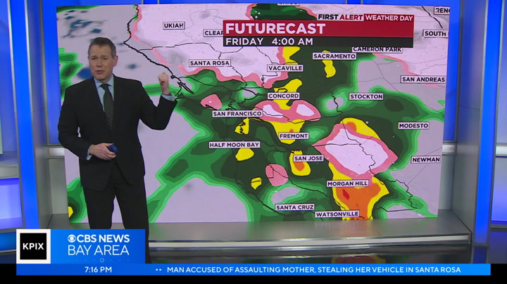
east bay hills, including eastern santa clara hills as well. going to be under a winter storm advisory. and we're going to see severe weather with the threat of hail if any pop-up thunderstorms do form gusty winds 50 miles per hour or less impacting your monday morning and monday afternoon commute. so just keep that in mind by monday night. that second storm going to exit only to be replaced by 3rd storm tuesday morning through wednesday morning. so we're going to see at least an inch of additional rain for the bay area from coast to valleys. right now, we're tracking a very dry, clear and cool outlook. half moon cooling down to 39 degrees with fairfax currently in the mid 30's at 34 degrees in petaluma dipping into the upper 30's overnight lows tonight below freezing for santa rosa. 31 degrees with widespread mid to upper 30's for the rest of our inland valleys. high temperatures tomorrow, very similar to today upper 40's to low 50's when we should be in the low to mid 60's 5 to 15 degrees below average. getting a little bit of a break from th
east bay hills, including eastern santa clara hills as well. going to be under a winter storm advisory. and we're going to see severe weather with the threat of hail if any pop-up thunderstorms do form gusty winds 50 miles per hour or less impacting your monday morning and monday afternoon commute. so just keep that in mind by monday night. that second storm going to exit only to be replaced by 3rd storm tuesday morning through wednesday morning. so we're going to see at least an inch of...
0
0.0
Feb 22, 2023
02/23
by
KPIX
tv
eye 0
favorite 0
quote 0
bay hills. a few inches of snow on top of mt. diablo and with heavier amounts further north into northern sonoma and napa counties and hefty commissions on top of that for much of inland mendocino county and lake county. most of us in the lower elevations, below 1000 feet, which is where the bulk of the bay area's population lives will see 1 to 1 1/2 inches of total rainfall. this should make a difference in terms of long-term drought conditions but it will be a cold and and pleasant rain that falls thursday to friday. temperature is not dropping down to the 30s inland with 40s around the bay. highs tomorrow don't warm-up a lot. highs topping out in the upper 40s and 50s but that is a solid 15 degrees below average, even by late february standards. alert days the next three days, we get a break in the action on saturday, and then another sequence of systems will be dropping down towards us with more shower activity for sunday, monday, and into tuesday of next week. even the potential for lowerin
bay hills. a few inches of snow on top of mt. diablo and with heavier amounts further north into northern sonoma and napa counties and hefty commissions on top of that for much of inland mendocino county and lake county. most of us in the lower elevations, below 1000 feet, which is where the bulk of the bay area's population lives will see 1 to 1 1/2 inches of total rainfall. this should make a difference in terms of long-term drought conditions but it will be a cold and and pleasant rain that...
0
0.0
Feb 22, 2023
02/23
by
KNTV
tv
eye 0
favorite 0
quote 0
we're already seeing snow on mount hamilton right now, as well as parts of the east bay hills. we can see that really coming down and we'll be tracking that with stormranger as it continues to accumulate. elsewhere it's pretty dry and the sky is clear. we're looking at estimated snowfall totals about 1 to 3 inches, and including the santa cruz mountains. mount diablo, as well as mount st. helena. it's very spotty today. i do expect the activity to start to ramp up tomorrow afternoon. that's when much more of the bay area is going to see rain and wintery weather in the mix as well. where you see the white and the pink, that's wintery mix and snow and green shows the rain that starts to taper off on saturday. overall we're looking at several storm systems coming in over the next few days. more widespread rain between thursday night and friday. then it tapers off briefly on saturday before another storm system comes in on sunday, another one right behind that on monday. you can see the picture here. it's going to be cold and wet through at least next week and we have a possibility
we're already seeing snow on mount hamilton right now, as well as parts of the east bay hills. we can see that really coming down and we'll be tracking that with stormranger as it continues to accumulate. elsewhere it's pretty dry and the sky is clear. we're looking at estimated snowfall totals about 1 to 3 inches, and including the santa cruz mountains. mount diablo, as well as mount st. helena. it's very spotty today. i do expect the activity to start to ramp up tomorrow afternoon. that's...
0
0.0
Feb 21, 2023
02/23
by
KPIX
tv
eye 0
favorite 0
quote 0
now look at the east bay hills. light shades of blue. this is from most likely, from wednesday night late to about friday morning that this will happen. and it wouldn't be big accumulations, but the snow level in that window of time gets down to about 1000 feet, you could get a light dusting of snow on some of the higher ridge tops there through the east bay hills. that would get a lot of attention, people would be talking about it but it would not have a huge impact like snow in the santa cruz mountains. you can see where you get some oranges and yellows on here. on some of those higher elevations on the draw through the santa cruz mountains, we get snow that could accumulate to a couple of inches, maybe, if this comes together. that takes us from thursday into friday morning, that window. so, we will be watching this very closely. we will be fine-tuning and refining the forecast on this as we get closer to it. there are other things to talk about, though, in terms of what is coming our way. snow in the sierra, obviously, this is from t
now look at the east bay hills. light shades of blue. this is from most likely, from wednesday night late to about friday morning that this will happen. and it wouldn't be big accumulations, but the snow level in that window of time gets down to about 1000 feet, you could get a light dusting of snow on some of the higher ridge tops there through the east bay hills. that would get a lot of attention, people would be talking about it but it would not have a huge impact like snow in the santa cruz...
0
0.0
Feb 24, 2023
02/23
by
KRON
tv
eye 0
favorite 0
quote 0
winter storm warning still in effect above 1000 feet for the bay area, north bay hills, east bay hills in the south bay mountains, all still under them. freeze warnings and frost advisories for another hour until 09:00am this morning with temperatures still in the 30's right now, snow accumulation does stay mostly in upper elevations until you get to northern sonoma and napa counties, then you get up into lake and mendocino counties and it is just winter in full force up there. nothing but snowfall resulting in some road closures that direction. now, futurecast pockets of rainfall and snow for that matter through the rest of the morning, we gradually see more and more sunshine. the later in the day you get by the afternoon. you do have a good dose of sun and between a few of those darker clouds. tomorrow we start the day with a few showers and then dry out consistently the rest of your saturday before resurgence of rainfall into sunday monday and tuesday of next week. we do have another inch of rainfall to be expected today tomorrow morning into sunday and early monday, adding even mor
winter storm warning still in effect above 1000 feet for the bay area, north bay hills, east bay hills in the south bay mountains, all still under them. freeze warnings and frost advisories for another hour until 09:00am this morning with temperatures still in the 30's right now, snow accumulation does stay mostly in upper elevations until you get to northern sonoma and napa counties, then you get up into lake and mendocino counties and it is just winter in full force up there. nothing but...
10
10.0
Feb 17, 2023
02/23
by
KRON
tv
eye 10
favorite 0
quote 0
right now, the east bay hills camera showing you the clear skies. we have not looking at a foggy start, but another cold start. we're in the 30's for areas like san mateo, redwood city, down through mountain view, fremont on inland over to livermore and dublin and even half moon bay at the coast. also up in the north bay petaluma and santa rosa down at 35 degrees right now. sonoma all the way down to 33 degrees. so definitely a chilly start. not quite cold enough for frost advisories and freeze warnings, though, breezy out of the delta as well as at the coastline. most of us are on the calmer side of things this morning. we do see some offshore showers resulting in just a few sprinkles right along the coastline in sonoma county on up into mendocino county. these are going to skirt right past the bay area, though. so we're not really looking at the potential in the bay area today.
right now, the east bay hills camera showing you the clear skies. we have not looking at a foggy start, but another cold start. we're in the 30's for areas like san mateo, redwood city, down through mountain view, fremont on inland over to livermore and dublin and even half moon bay at the coast. also up in the north bay petaluma and santa rosa down at 35 degrees right now. sonoma all the way down to 33 degrees. so definitely a chilly start. not quite cold enough for frost advisories and freeze...
12
12
Feb 17, 2023
02/23
by
KRON
tv
eye 12
favorite 0
quote 0
right now, the east bay hills camera showing you the clear skies. we have not looking at a foggy start, but another cold start. we're in the 30's for areas like san mateo, redwood city, down through mountain view, fremont on inland over to livermore and dublin and even half moon bay at the coast. also up in the north bay petaluma and santa rosa down at 35 degrees right now. sonoma all the way down to 33 degrees. so definitely a chilly start. not quite cold enough for frost advisories and freeze warnings, though, breezy out of the delta as well as at the coastline. most of us are on the calmer side of things this morning. we do see some offshore showers resulting in just a few sprinkles right along the coastline in sonoma county on up into mendocino county. these are going to skirt right past the bay area, though. so we're not really looking at the potential in the bay area today. that system just traveling too far to the west for us. so what we've got is increasingly clear skies by the afternoon, mostly sunny, nice conditions. daytime highs pushing
right now, the east bay hills camera showing you the clear skies. we have not looking at a foggy start, but another cold start. we're in the 30's for areas like san mateo, redwood city, down through mountain view, fremont on inland over to livermore and dublin and even half moon bay at the coast. also up in the north bay petaluma and santa rosa down at 35 degrees right now. sonoma all the way down to 33 degrees. so definitely a chilly start. not quite cold enough for frost advisories and freeze...
0
0.0
Feb 27, 2023
02/23
by
KRON
tv
eye 0
favorite 0
quote 0
and as you could see for our east bay hills, including the mount diablo range, getting that mixture of rain and snow showers. but it's going to be this second stronger storm out in the pacific northwest. that's going to bring us widespread rain and also some pretty severe weather as well. in addition to snow for the north bay mountains monday morning. we're also going to see pop-up thunderstorms, hail and gusty winds 50 miles per hour or less making for a dangerous monday morning commute. calmer conditions by monday afternoon. but don't put away your umbrella just yet, because as you can we're still tracking some scattered showers with round 3 arriving tuesday morning. more. my full forecast coming up in just a few minutes. stand and walk back to you. >> despite the rain, a big turnout today in san jose and supportive to street food vendors who were attacked in recent weeks. all the money from today's cookout will go directly to the 2 men. it comes as one of the attackers is apologizing for their actions. kron 4 sarah stinson reports. >> rain or shine people really showed up in san jos
and as you could see for our east bay hills, including the mount diablo range, getting that mixture of rain and snow showers. but it's going to be this second stronger storm out in the pacific northwest. that's going to bring us widespread rain and also some pretty severe weather as well. in addition to snow for the north bay mountains monday morning. we're also going to see pop-up thunderstorms, hail and gusty winds 50 miles per hour or less making for a dangerous monday morning commute....
0
0.0
Feb 23, 2023
02/23
by
KPIX
tv
eye 0
favorite 0
quote 0
even higher amounts around the edges of the bay area, maybe some accumulation around the east bay hills. if you travel on california 24 through the caldecott tunnel, there will be a layer of flakes on the ground, but higher amounts through the north bay mountains as well. so all the highways through the higher elevations, you want to avoid those. for most of the bay area, anywhere from a half inch to over an inch of rain. a lot of that aimed at the southern end of the bay area , just where the second round of moisture will be aimed on friday night into early saturday. it will also be called. temperatures tonight dropping down into the 30s areawide. even downtown san francisco dipping down into the upper 30s for low temperatures. you want to get your dogs out for a walk tomorrow, pickle and lilac won't have a lot of sunshine to bask in tomorrow, but still, where the pups out tomorrow. it will still be cold and breezy. temperatures will not warm up very much. only upper 40s to around 50 degrees for highs thursday afternoon. our temperatures don't warm up very much through the entirety of
even higher amounts around the edges of the bay area, maybe some accumulation around the east bay hills. if you travel on california 24 through the caldecott tunnel, there will be a layer of flakes on the ground, but higher amounts through the north bay mountains as well. so all the highways through the higher elevations, you want to avoid those. for most of the bay area, anywhere from a half inch to over an inch of rain. a lot of that aimed at the southern end of the bay area , just where the...
0
0.0
Feb 22, 2023
02/23
by
KPIX
tv
eye 0
favorite 0
quote 0
bay hills around morocco. the level of the caldecott tunnel is about 1400 feet which is right about the level we are forecasting the snow line to drop too. slick conditions to start the day on friday and higher amounts for the north. northbay mountains around mt. st. helena, northern sonoma and napa counties and inland mendocino county and lake county picking up quite a bit more snow on the system. the rest of the area would most of us will see is snow in the distance and rain falling on our heads. around one did inch of rain by and there is a winter storm warning with a winter weather advisory around lake tahoe itself. 1 to 3 feet of snow over the next several days, this goes all the way through early saturday morning. snow levels falling very low in elevation there as 1000 to 2000 feet but very gusty wind which we certainly have now. whitecaps out of the day, temperatures are quite a bit colder than 24 hours ago. upper 40s and 50s right now, we dropped to the 30s and lower 40s by early tomorrow morning and w
bay hills around morocco. the level of the caldecott tunnel is about 1400 feet which is right about the level we are forecasting the snow line to drop too. slick conditions to start the day on friday and higher amounts for the north. northbay mountains around mt. st. helena, northern sonoma and napa counties and inland mendocino county and lake county picking up quite a bit more snow on the system. the rest of the area would most of us will see is snow in the distance and rain falling on our...
0
0.0
Feb 14, 2023
02/23
by
KRON
tv
eye 0
favorite 0
quote 0
. >> from the east bay hills looking down into the bay yesterday. at this point, you're seeing that dense fog just settling right in there today. much different. so it is clear, but it is really windy. and that is contributing to a very brisk feel. even if you are in the 40's right now. yeah, feel colder than that. when you factor in windchill san mateo timber on santa rosa at 41. all livermore to dublin, vallejo and napa among spots in the upper 30's. take a look at some of these winds. half moon bay been seeing winds gusting regularly into a 40 mile per hour range. sandra fell petaluma even san francisco and oakland seeing winds gusting up to a 20 to 30 mile per hour range and that contributes to this very brisk feel this morning. you're really going to feel those winds on your bridges as well as on mountain passes as you make the commute into work. now i'm going to be talking a colder afternoon for your valentine's day. all those details still to come in your forecast rain. all right, john, thanks for that. let's check on those bridges. 14 minute
. >> from the east bay hills looking down into the bay yesterday. at this point, you're seeing that dense fog just settling right in there today. much different. so it is clear, but it is really windy. and that is contributing to a very brisk feel. even if you are in the 40's right now. yeah, feel colder than that. when you factor in windchill san mateo timber on santa rosa at 41. all livermore to dublin, vallejo and napa among spots in the upper 30's. take a look at some of these winds....
0
0.0
Feb 25, 2023
02/23
by
KTVU
tv
eye 0
favorite 0
quote 0
of nations reporting up to six inches in the east bay hills a few inches at about 700 ft. and in the santa cruz mountains, a few inches down about 700 ft. the higher elevations above 2500 ft. got anywhere from 10 inches of snow to a foot of snow. so quite impressive and historic day for the bay area. here's a look at where we're still seeing that snow in the sierra for us. we have calmed down quite a bit. we have a little bit of snow reported over cobb mountain in the north bay and then a little bit going on right over the mountain hamilton's area in the south bay. the future cast here will show you the wraparound showers don't stop completely. here's a look at the overnight hours where we are seeing some light rain steadyain passed through and then tomorrow morning. mostly cloudy, mainly.. mostly cloudy, mainly dry and then into the afternoon and evening hours. mostly cloudy, mainly dry saturday is going to be the break another storm coming in on sunday. as far as what we do expect for tomorrow morning, the headline could shift over to just how cold it is with advisories
of nations reporting up to six inches in the east bay hills a few inches at about 700 ft. and in the santa cruz mountains, a few inches down about 700 ft. the higher elevations above 2500 ft. got anywhere from 10 inches of snow to a foot of snow. so quite impressive and historic day for the bay area. here's a look at where we're still seeing that snow in the sierra for us. we have calmed down quite a bit. we have a little bit of snow reported over cobb mountain in the north bay and then a...
0
0.0
Feb 27, 2023
02/23
by
KGO
tv
eye 0
favorite 0
quote 0
bay hills and santa clara hills. so this winter weather advisory is in effect in the east bay and southbay hills from 10:00 p.m. tomorrow until 4:00 p.m. tuesday. more on the weather coming up this week in just a moment. spencer, thank you. crews are working to restore power after a week of dry wet weather brought down trees and power lines. at last check, more than 4000 customers were without electricity. across the state, 120,000 people lost electricity today. contra costa county residents impacted by the series of winter storms in december and january, still have time to apply for federal assistance. in disaster recovery center opened today at the civic center. residents can apply in person from 8:00 a.m. to 6:00 p.m.. the center will be open through february, and it will then move to community presbyterian church in pittsburgh. don't forget, you can always track of weather conditions and access the same live doppler 7 that our own uses, anytime you want. you can find it on demand on the abc7 bay area app. a speci
bay hills and santa clara hills. so this winter weather advisory is in effect in the east bay and southbay hills from 10:00 p.m. tomorrow until 4:00 p.m. tuesday. more on the weather coming up this week in just a moment. spencer, thank you. crews are working to restore power after a week of dry wet weather brought down trees and power lines. at last check, more than 4000 customers were without electricity. across the state, 120,000 people lost electricity today. contra costa county residents...
0
0.0
Feb 21, 2023
02/23
by
KRON
tv
eye 0
favorite 0
quote 0
so you want to keep that in mind. >> here's a live picture from the east bay hills. you can see cloudy skies and this tuesday morning and we do have some high winds in the forecast. that's going to start today in this afternoon around 01:00pm. and then that's going to go into effect until wednesday tomorrow. 01:00pm for the entire bay area. so we're talking wind gusts of 25 to 35 miles per hour and gusts up to 55 miles per hour in the higher elevations. so this is really the start of our active weather pattern we're seeing from that cold front moving over the region, stormtracker for it, not showing much activity today, but futurecast for changes, especially when you have into wednesday. that's when we're going to see some showers that will be impacting the coast and then the showers do continue until thursday and even friday. and you may even notice some of that blue and pink and we're seeing some snow on the mountain tops and is stings a line. you could see some snowflakes on the lower valleys. yeah, you want to prepare for wednesday, thursday and friday. as for th
so you want to keep that in mind. >> here's a live picture from the east bay hills. you can see cloudy skies and this tuesday morning and we do have some high winds in the forecast. that's going to start today in this afternoon around 01:00pm. and then that's going to go into effect until wednesday tomorrow. 01:00pm for the entire bay area. so we're talking wind gusts of 25 to 35 miles per hour and gusts up to 55 miles per hour in the higher elevations. so this is really the start of our...
0
0.0
Feb 13, 2023
02/23
by
KRON
tv
eye 0
favorite 0
quote 0
so therefore, you might have a little flakes tossed about around the east bay hills, just a touch, although there will be some snow up in the mountains and then cold. after all of that, as we're going to spear some chilly morning lows. that's where you're really going to feel. nice bite in the air. remind you that. yes, february is a winter months to come. those onshore winds do from the northwest, as you will notice, really building quite a bit along the coastal strip. but you can feel a little solano county, after all said and done coming in from the northerly direction. highs will go with around the mid 60's at best lower to middle 60's at that. here's your seven-day forecast in the big drop we're talking about 52. that's on highs for an isolated shower. we'll see some lower 30's there for the next couple of days with 40's of the coast. well. dave, thank you. >> take a look at this. a 6 month-old puppy jumped out of a car window onto a busy freeway in la county. here's the video. the puppy makes a miracle landing. there he goes. the dangerous close call happened in woodland hills. the he
so therefore, you might have a little flakes tossed about around the east bay hills, just a touch, although there will be some snow up in the mountains and then cold. after all of that, as we're going to spear some chilly morning lows. that's where you're really going to feel. nice bite in the air. remind you that. yes, february is a winter months to come. those onshore winds do from the northwest, as you will notice, really building quite a bit along the coastal strip. but you can feel a...
27
27
Feb 18, 2023
02/23
by
KRON
tv
eye 27
favorite 0
quote 0
little dusting along the east bay hills. this is probably our last shot of said he had with certainly this cold system we're looking at storm tracker 4. this is where it's going to come from up here in the gulf of alaska. right now it's being blocked. it's not really well developed that will come later. 60 san francisco about 63 for oakland. 66 san jose. lot of middle to lower 60's to be had for high temperatures for today. again, we're going up that tomorrow. but boy, some really winter weather going on free into next week. we'll have more on those details coming up in a bit, stephanie. all right, dave, thank you. >> the suspect in last week's deadly explosion at a home in san francisco will be released on house arrest. he appeared back in court friday and faces a string of felony charges. kron four's gayle ong reports. >> at a friday morning arraignment, the judge ruled 53 year-old darron price was criminally careless about last week's house explosion in san francisco's outer sunset district. but does not need to be detain
little dusting along the east bay hills. this is probably our last shot of said he had with certainly this cold system we're looking at storm tracker 4. this is where it's going to come from up here in the gulf of alaska. right now it's being blocked. it's not really well developed that will come later. 60 san francisco about 63 for oakland. 66 san jose. lot of middle to lower 60's to be had for high temperatures for today. again, we're going up that tomorrow. but boy, some really winter...
102
102
Feb 23, 2023
02/23
by
KGO
tv
eye 102
favorite 0
quote 2
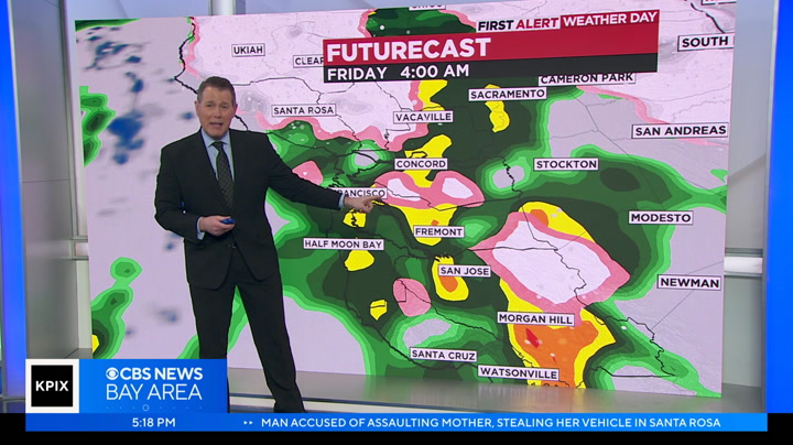
in the east bay hills. caltrans is advising people to be cautious about that if you see any on the roadway since we don't see a lot of snow here. they say you any otheldr road ouhazard.>> cee are used to. >> in the north, they are expected to see a few inches of snow as early as tonight. leah melendez is live from panoramic highway with how they are preparing. >> it is a little bit here. 39 degrees right now. people are excited. we are not in tahoe but they hope it will snow. the last time it snowed here was back in february of 2019. about 100 years ago in mill valley had a big snowstorm, six inches. >> as the marin county significantly died down late this morning, crews were able to remove some of the fallen trees and branches from the night before, the concern is the antipacid snow, possibly even falling on some of the lower elevation areas. >> i would say stay away. it is very rare to get snow up here. drive like you are in the mountains and use the corrected defensive driving. >> even without snow, the
in the east bay hills. caltrans is advising people to be cautious about that if you see any on the roadway since we don't see a lot of snow here. they say you any otheldr road ouhazard.>> cee are used to. >> in the north, they are expected to see a few inches of snow as early as tonight. leah melendez is live from panoramic highway with how they are preparing. >> it is a little bit here. 39 degrees right now. people are excited. we are not in tahoe but they hope it will snow....
0
0.0
Feb 24, 2023
02/23
by
KTVU
tv
eye 0
favorite 0
quote 0
looks like sfo and then shifting over into the east bay over the east bay hills. let's get into the mountain. mountains of the sierra, where again the snow continues here, and the advisories for travel continue here has gasia mentioned just a moment ago. i 80 open, at least for now. but this winter storm got warning goes all the way until early tomorrow morning, so still going to be a treacherous one up there and the winter weather advisory will continue for the sierra for us. one advisory remains at this time, and it looks like they actually allowed it to expire. that was supposed to be a wind advisory for parts of solano county. going until this afternoon at four o'clock, but at least for now, i do see that they actually removed that so good news. there better details on what we can expect. for today . how much rainfall we have seen how much snowfall we have seen and what we're looking at is we get into the weekend coming up. thank you. rosemary notice some new video we shot this morning of snow and mount diablo. it is a difficult place to get to right now becau
looks like sfo and then shifting over into the east bay over the east bay hills. let's get into the mountain. mountains of the sierra, where again the snow continues here, and the advisories for travel continue here has gasia mentioned just a moment ago. i 80 open, at least for now. but this winter storm got warning goes all the way until early tomorrow morning, so still going to be a treacherous one up there and the winter weather advisory will continue for the sierra for us. one advisory...
0
0.0
Feb 6, 2023
02/23
by
KPIX
tv
eye 0
favorite 0
quote 0
another strike slip fault that goes through the east bay hills. they put out kind of the visual description of what might happen in a 7.0 which is one of the more possible scenarios. the deeper the shade of red shows the higher amount of energy that will emanate out from the rupture on that fault at home. it would not be anywhere near as bad as the pictures from turkey. we have improved construction practices, light years ahead of where we were and well ahead of where turkey is. they are looking at 3000 deaths and above. the number will likely go higher. at home, if we were to get that 7.0 earthquake, we could be looking at as many as 800 deaths. it is not fun statistics. on days like today, these are the opportunities where we should talk about it and at least bring it home in terms of we all live on a vulnerable fault that is a strike slip. also the possible numbers. be 18,000 injured. that is just one possibility. >>> it is so good to be aware. others that are holding light, -- tweeted this message. he said apple will be donating to the relief
another strike slip fault that goes through the east bay hills. they put out kind of the visual description of what might happen in a 7.0 which is one of the more possible scenarios. the deeper the shade of red shows the higher amount of energy that will emanate out from the rupture on that fault at home. it would not be anywhere near as bad as the pictures from turkey. we have improved construction practices, light years ahead of where we were and well ahead of where turkey is. they are...
0
0.0
Feb 21, 2023
02/23
by
KPIX
tv
eye 0
favorite 0
quote 0
also in the east bay hills, that's well above 1,000 feet. it's a first alert weather day in the bay area today. here is why. national weather service, that's not what i wanted to show, national weather service issued wind advisory due to the fact that we are seeing gusts up to 50 miles per hour. take a look. this is the 10:00 a.m. hour. this is within the next five hours. we are seeing wind gusts up to 30 miles per hour. that's manageable, no big deal. what we don't like is when it is past that. we can see gusts up it 50 miles per hour by 1:00 ar s gust the east s. notice ilights ba area iur. this is during many people's commute time home from work. we just got back to work today after the long weekend. be careful on the roads. don't rush home. you need to take it slow into the afternoon hours today. that wind advisory lasts until 1:00 tomorrow. we'll have more on that in a bit. for now, at least it is not impacting roads to the extent that we will be seeing later on. >> so that afternoon commute today and then tomorrow morning's commute mig
also in the east bay hills, that's well above 1,000 feet. it's a first alert weather day in the bay area today. here is why. national weather service, that's not what i wanted to show, national weather service issued wind advisory due to the fact that we are seeing gusts up to 50 miles per hour. take a look. this is the 10:00 a.m. hour. this is within the next five hours. we are seeing wind gusts up to 30 miles per hour. that's manageable, no big deal. what we don't like is when it is past...
0
0.0
Feb 22, 2023
02/23
by
KPIX
tv
eye 0
favorite 0
quote 0
bay hills. we could see anywhere up to 15 inches of snow near lexington hill. 20 inches at the peak of mount hamilton. >>> there are a lot of branches in the roadways, as you were out and about this morning. i was driving in this morning, and you could see that. be extra careful. let's talk about the bay bridge. unfortunately, they were big issues at the bay bridge. they troubles because of trees down in the roadway. everything is clear and that is good news. you can take the bay bridge this morning and everything is looking better. here is a look at current traffic conditions. if you are working your way across the bridge. it is windy. there is a traffic alert on 80 eastbound at pomona street. a traffic alert has been issued. let's look at the bay bridge. this was yesterday. you can see the bay bridge, was a mess at rush hour after a tree fell across the westbound lane. the lanes were eventually cleared, but it took hours for traffic to ease up. in san francisco, this is a corvette that was sma
bay hills. we could see anywhere up to 15 inches of snow near lexington hill. 20 inches at the peak of mount hamilton. >>> there are a lot of branches in the roadways, as you were out and about this morning. i was driving in this morning, and you could see that. be extra careful. let's talk about the bay bridge. unfortunately, they were big issues at the bay bridge. they troubles because of trees down in the roadway. everything is clear and that is good news. you can take the bay...
0
0.0
tv
eye 0
favorite 0
quote 0
frances: here is a live shot from the east bay hills, it is gorgeous right now. temperatures are chilly, dropping into the mid-30's, especially for parts of the north bay. here is a look at temperatures. i this afternoon, we will see warmer temperatures compared to yesterday. i will let you know what to expect after the break. ♪ it's time to bring balance to business travel. and discover the equilibrium that works for you. at national, you're in control. skip the counter, choose any car in the aisle... and manage your rental right from the app. so you can mix work... with leisure. or leisure... with work. giving you the control to find the perfect balance. go national. go like a pro. business can happen anytime, anywhere. so help yours thrive and stay connected with the comcast business complete connectivity solution. it's the largest, fastest, reliable network. advanced gig speed wifi. and cyberthreat protection. starting at just $49.99 a month. plus, you can save up to 60% a year when you add comcast business mobile. or, ask how to get up to a $750 prepaid ca
frances: here is a live shot from the east bay hills, it is gorgeous right now. temperatures are chilly, dropping into the mid-30's, especially for parts of the north bay. here is a look at temperatures. i this afternoon, we will see warmer temperatures compared to yesterday. i will let you know what to expect after the break. ♪ it's time to bring balance to business travel. and discover the equilibrium that works for you. at national, you're in control. skip the counter, choose any car in...
 Live Music Archive
 Librivox Free Audio
 Metropolitan Museum
 Cleveland Museum of Art
 Internet Arcade
 Console Living Room
 Books to Borrow
 Open Library
 TV News
 Understanding 9/11